Earth AI is shaping tomorrow’s world, today, itself as it has developed artificial intelligence which meets essential needs of the world by predicting natural disasters, to finding out hidden minerals beneath the Earth’s surface. Earth AI is preparing itself and the environment for situations(traffic, water blocking, digging holes, etc) in advance. These are powered by satellite, data, and deep learning, which gives us a bird’s-eye view of change, progress, and possibility.
Why Use Earth AI?
Google Earth AI uses artificial intelligence and takes Earth data from this, including satellite images, weather, and population, to understand our planet better.
- AI and satellite data are making global mapping faster and smarter.
- Google Earth AI uses advanced models to bring huge amounts of satellite data. It automatically shows you buildings, roads, and land cover, even though clouds are wandering, Earth AI keeps the map constantly updated.
- Earth AI helps in mineral exploration by analysing satellite images to find signs of valuable minerals. This makes discovering new sites quick and more accurate.
All these are benefits of Earth AI and showcase its sustainability and efficiency. It reduces the cost, time, and environmental impact of exploration while supporting the world’s shift to clean energy.
What is Geospatial Intelligence?
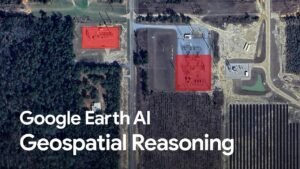
Google Earth AI uses geospatial intelligence, which helps Earth AI study and interpret satellite imagery to find areas rich in minerals and track environmental changes.
By using images of Earth from satellites or drones, AI calculates location data to understand what is happening on Earth and help them to make the next step smartly. It’s intelligence (knowledge) about human activities and the Earth’s surface area gained by studying maps and images.
- Imagery:
Photos or videos from satellites, planes, or drones that show what Earth looks like.
- Geospatial Information:
Data connected to locations like roads, cities, borders, and population maps.
- Imagery Intelligence
Studying those images carefully to find where the places are situated like where buildings, cars, or forests are.
- Data Integration:
GEOINT combines satellite images, geological maps, and remote sensing data to create a complete picture of the Earth’s surface.
- Environmental Monitoring:
It also tracks changes in land use, vegetation, and nearby ecosystems to ensure exploration remains eco-friendly.
- Decision Support:
The insights from GEOINT guide scientists and engineers to choose the best drilling spots while minimising environmental impact.
Satellite Imagination in Google Earth AI
AI uses its technology beyond your imagination here. When combined with AI, satellite imagery becomes the foundation of technologies that supply Google data by discovering both above and below the surface.
- Earth AI’s role in your area
AI takes a photo of your building, society, and if it tracks any change in your area, it updates over time.
- It plays a significant role in delivering information about natural disasters in advance
By tracking deforestation in the Amazon to identify flooded villages within hours, satellite imagery makes it possible to see what’s happening anywhere on Earth.
- For Industrial purposes
AI marks the most important step as it finds out spots to dig, saving money and time.
AI studies the invisible “fingerprints” (only detected by advanced devices) to find hints of valuable minerals below the ground. They study soil moisture, vegetation health, and mineral presence.
Hence, when it is confirmed by workers, they use eco-friendly drilling machines.
Mapping in Google Earth AI
AI finds and draws on a real-time basis:
- Buildings
- Roads
- Land types include forests, water, and cities
- Helps track changes such as urban growth.
- Deforestation
It automatically identifies features like roads, buildings, and forests from satellite images.
This technology is faster and more accurate than traditional manual surveys. It creates mineral prospectivity maps that show areas likely to contain valuable minerals. These AI-generated maps guide scientists directly to the most promising exploration sites, saving time and reducing environmental damage. The ultimate goal is to keep maps accurate and current.
Environmental Analysis
Environmental Analysis is the study of how human activities and natural processes affect the Earth’s ecosystems.
It involves observing and analysing environmental factors to protect the balance between development and ecology.
- Sustainable Mineral Exploration
Earth AI focuses on discovering minerals
- Reduced Land Disturbance
It identifies high-potential mineral zones before drilling, which means less land is disturbed.
- Monitoring Environmental Impact
Satellite imagery allows exploration to remain eco-safe.
- Efficient Resource Use
helps in saving energy, time, and cost while maintaining environmental balance.
- Global Sustainability Alignment
supports the UN Sustainable Development Goals (SDGs)
Conclusion
Earth AI is a modern technology that uses artificial intelligence, satellite images, and earth science to make finding minerals smarter and easier. Earth AI is helping to create a greener and more sustainable future. Earth AI’s system also spots changes happening around societies and natural areas, keeping maps up to date with new roads, land use, or construction. It’s smart mapping ensures both progress and protection
FAQs
Is Google Maps using AI now?
Yes, Google Maps is using AI for features like Immersive View, better routing, and Gemini-powered reasoning.
Is Google Earth an AI?
Google Earth has new “Earth AI” models for things like flood forecasting, disaster alerts, and satellite imagery.
What are the features of Google Earth AI?
Natural-language querying of satellite data, change detection, weather predictions, and mapping infrastructure risks.
Can I invest in Earth AI?
Not really, Earth AI is a product from Google, not a separate company you can buy stock in.